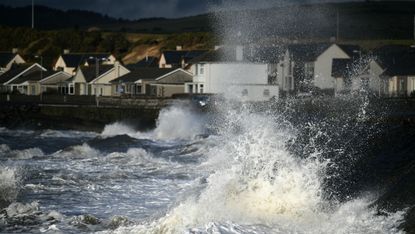
Storm Diana: how bad is it?
The high winds and heavy rain began on Tuesday evening and will continue into Thursday

The Met Office has issued yellow weather warnings for today and tomorrow as Storm Diana gathers pace across the UK.
Forecasters are predicting very windy weather throughout the country today, with a blast of strong winds and gales set to hit the North and West. Widespread rain is expected, with the heaviest showers likely to fall over Scotland and Northern Ireland.
“You’ll have misty and murky conditions across the UK on Thursday,” says Alex Deakin, a meteorologist for the Met Office. “For most, it’s one more cold day, feeling particularly cold as the storm pushes into Northern Ireland. The wind has potential to do some damage, especially on Wednesday and Thursday. We have warnings in force.”
Subscribe to The Week
Escape your echo chamber. Get the facts behind the news, plus analysis from multiple perspectives.

Sign up for The Week's Free Newsletters
From our morning news briefing to a weekly Good News Newsletter, get the best of The Week delivered directly to your inbox.
From our morning news briefing to a weekly Good News Newsletter, get the best of The Week delivered directly to your inbox.
The storm, named Storm Diana by the IPMA Portuguese weather service, could cause “damage to property or dangerous flooding”, reports the Daily Mirror.
Areas affected by the yellow warnings include Wales, southwest England, northwest England, Northern Ireland, the Highlands and Eilean Siar, and southwest Scotland. Strong winds could result in travel delays and power failures up until Thursday afternoon.
Engineers from Network Rail will be on standby to tackle any incidents on Britain’s railways, Sky News reports. “Floods, high winds and landslips can destroy railway infrastructure and block lines, so our teams repair damage and clear debris to ensure trains can continue to run,” said a spokesperson for the company.
The storm is expected to bring between 60mm and 80mm of rain, while winds could reach speeds of up to 130km/h.
The gusty wet weather is forecast to continue into the weekend.
Create an account with the same email registered to your subscription to unlock access.
Sign up for Today's Best Articles in your inbox
A free daily email with the biggest news stories of the day – and the best features from TheWeek.com
-
 Cicada-geddon: the fungus that controls insects like 'zombies'
Under The Radar Expert says bugs will develop 'hypersexualisation' despite their genitals falling off
By Chas Newkey-Burden, The Week UK Published
-
 'Voters know Biden and Trump all too well'
Instant Opinion Opinion, comment and editorials of the day
By Harold Maass, The Week US Published
-
 Is the Gaza war tearing US university campuses apart?
Today's Big Question Protests at Columbia University, other institutions, pit free speech against student safety
By Joel Mathis, The Week US Published
-
 Richard Branson’s Virgin Galactic and Jeff Bezos’s Blue Origin: the new space race?
Speed Read Branson has declared space open for business. Is that still a pie in the sky?
By The Week Staff Published
-
 Russia and China joining forces to build first Moon base
Speed Read Lunar pact represents ‘all kinds of security threats’ to UK and US, expert warns
By Joe Evans Last updated
-
 Mystery of where Stonehenge stones came from finally solved
Speed Read But how the builders moved the huge stone megaliths to the Salisbury site remains a mystery
By Aaron Drapkin Last updated
-
 How chimpanzee ‘lip smacking’ can unlock mystery behind human speech
Speed Read New study reveals rhythm of great apes’ communications is identical to spoken language
By The Week Staff Published
-
 Could coronavirus lead to world peace?
Speed Read International leaders throw their weight behind plans for a global ceasefire – but will it hold?
By The Week Staff Last updated
-
What is an Earth sandwich?
Speed Read Two men create planet-sized snack by placing slices of bread on exact opposite sides of the planet
By The Week Staff Last updated
-
 Scientists discover new variety of black hole
Speed Read Astronomers had previously missed entire class of dead star
By James Ashford Last updated
-
 Trio win Nobel physics prize for work to understand cosmos
Speed Read The scientists were hailed for ‘ground-breaking’ discoveries
By The Week Staff Last updated