
Satellite image released by Amnesty International reveal the extent of the attacks carried out by terrorist group Boko Haram on towns in northern Nigeria earlier this month.

Subscribe to The Week
Escape your echo chamber. Get the facts behind the news, plus analysis from multiple perspectives.

Sign up for The Week's Free Newsletters
From our morning news briefing to a weekly Good News Newsletter, get the best of The Week delivered directly to your inbox.
From our morning news briefing to a weekly Good News Newsletter, get the best of The Week delivered directly to your inbox.
Boko Haram attack: massacre in Nigerian army town
Create an account with the same email registered to your subscription to unlock access.
-
 Caitlin Clark the No. 1 pick in bullish WNBA Draft
Speed Read As expected, she went to the Indiana Fever
-
 Today's political cartoons - April 16, 2024
Cartoons Tuesday's cartoons - sleepyhead, little people, and more
-
 Trump criminal trial starts with rulings, reminder
Speed Read The first day of his historic trial over hush money payments was mostly focused on jury selection


-
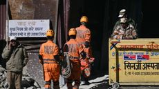 Puffed rice and yoga: inside the collapsed tunnel where Indian workers await rescue
Speed Read Workers trapped in collapsed tunnel are suffering from dysentery and anxiety over their rescue
-
 Gaza hospital blast: What the video evidence shows about who's to blame
Speed Read Nobody wants to take responsibility for the deadly explosion in the courtyard of Gaza's al-Ahli Hospital. Roll the tape.
-
 Giraffe poo seized after woman wanted to use it to make a necklace
Tall Tales And other stories from the stranger side of life
-
 Helicopter sound arouses crocodiles
Tall Tales And other stories from the stranger side of life
-
 Woman sues Disney over 'injurious wedgie'
Tall Tales And other stories from the stranger side of life
-
 Emotional support alligator turned away from baseball stadium
Tall Tales And other stories from the stranger side of life
-
 Europe's oldest shoes found in Spanish caves
Tall Tales And other stories from the stranger side of life
-
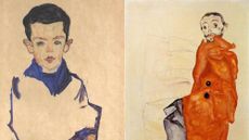 Artworks stolen by Nazis returned to heirs of cabaret performer
It wasn't all bad Good news stories from the past seven days


